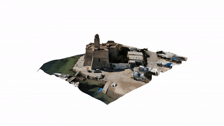
Thanks to a series of shots at different heights, it is possible to obtain a three-dimensional model. To be precise, three shooting cycles must be carried out at three different heights: at ground level, about halfway up the building and beyond the roof. Any other photograph taken at ground level will help to increase the detail and cover any areas of the tower possibly not captured by the drone. Some zenith shots were also made, again with the aid of the drone.
The technique is still in its infancy and presents some large approximations, but the application is nevertheless interesting, as it is a very fast process (In our case, a quarter of an hour of shooting allowed us to obtain a three-dimensional model of the tower and vicinity), immediate and, in addition to the 3D model, you can simultaneously take aerial shots of the building.
Once the three-dimensional model has been obtained, it is possible to extract the elevations, sections and the external profile of the plants. After having “cleaned” the 3D model of inaccuracies, it is possible to directly make a 3D print.
This project was realized in collaboration with Marea Studio.
LOCATION
Villanova, Italy
TYPOLOGY
3D scan
SIZE
150 m2
YEAR
2020